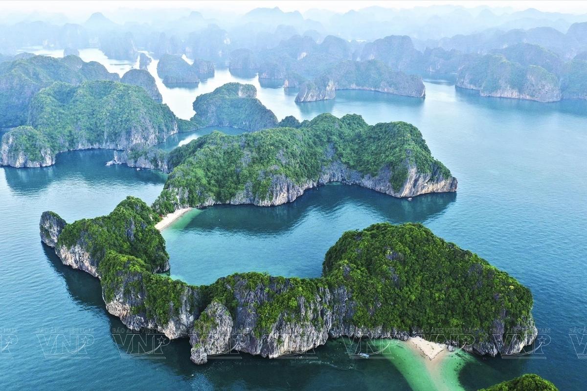
Halong Bay spans more than 1,500 square kilometres of the Gulf of Tonkin, and for many first-time visitors, that scale makes planning feel uncertain. Which islands are worth the detour? Does your cruise actually sail through the famous cave zone, or does it anchor somewhere quieter? And is the bay on the map one body of water or three?
This guide answers those questions with a geographic breakdown you can use before you book. We cover where Halong Bay sits on the map of Vietnam, how its three connected bays differ in character and access, where the best-known caves and islands are located, and how to read a cruise route map so your itinerary matches the experience you came for.
Where Is Halong Bay on the Map of Vietnam?
Halong Bay is located in Quang Ninh Province in northeastern Vietnam, along the western shore of the Gulf of Tonkin. It sits approximately 170 km (106 miles) from Hanoi and is reachable by road in around 2.5 hours via the Hanoi-Halong expressway.
- Province: Quang Ninh
- Distance from Hanoi: Approx. 170 km / 106 miles
- Travel time from Hanoi: Approx. 2.5 hours
- Total bay area: Approx. 1,553 sq km
- UNESCO core zone: Approx. 434 sq km
- Islands and islets: Over 1,600
- Coastline length: Approx. 120 km / 75 miles
The bay earned UNESCO World Heritage status in 1994. Its core protected zone covers approximately 434 square kilometres, while the wider bay area extends to around 1,553 square kilometres, home to more than 1,600 limestone islands and islets shaped over millions of years of karst erosion and sea level change.
The Three Bays on the Halong Bay Map
What most travellers call “Halong Bay” is a wider region containing three distinct bays. Understanding each one changes how you read a cruise map and, ultimately, which route you choose.
- Halong Bay is the central zone that runs along the coast of Halong City. It holds the UNESCO-designated core areas, including the bay’s most famous caves, its best-known viewpoints, and the majority of cruise departures. It is the most visited and most carefully regulated part of the wider region.
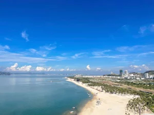
- Lan Ha Bay lies to the southeast, separated from Halong Bay proper by Cat Ba Island. Administratively, it falls under Hai Phong municipality rather than Quang Ninh Province, which gives cruise operators more flexibility in how they design their routes. As cruise capacity across the wider bay area has grown in recent years, with a larger number of big-capacity vessels now operating in Lan Ha Bay, its waters have become noticeably busier and now see crowd levels closer to those of Halong Bay proper during peak periods.
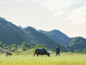
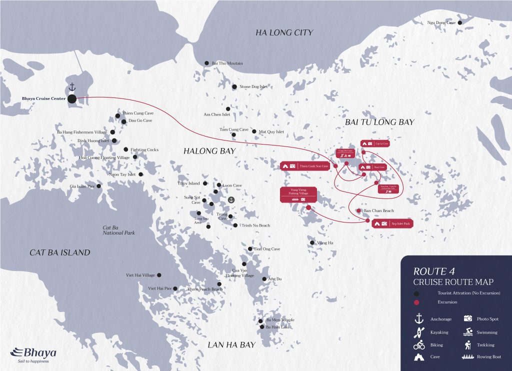
- Bai Tu Long Bay sits to the northeast of Halong Bay proper. It shares the same karst landscape but attracts far fewer vessels, making it the most remote of the three. It is home to fishing communities including Vung Vieng village and the dramatic Thien Canh Son Cave, and it suits travellers who want an off-the-beaten-track experience as part of a longer itinerary.
For travellers who want to experience both Halong Bay and Lan Ha Bay in a single voyage, The Au Co’s signature 3-day itinerary is one of the few routes in the region designed to cross both bodies of water.
Reading a Halong Bay Cruise Route Map
A Halong Bay cruise map tells you more than where the vessel travels. It shows where it anchors overnight, which shore excursions are within reach of each stop, and whether the itinerary stays in the well-known central zone or ventures into quieter, less-visited water.
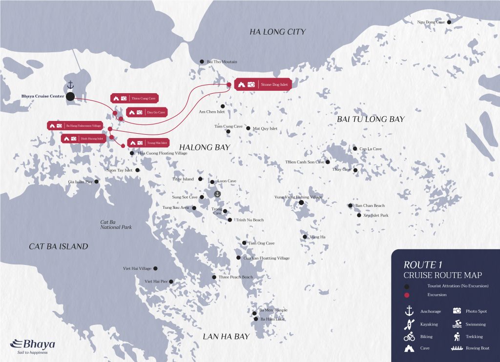
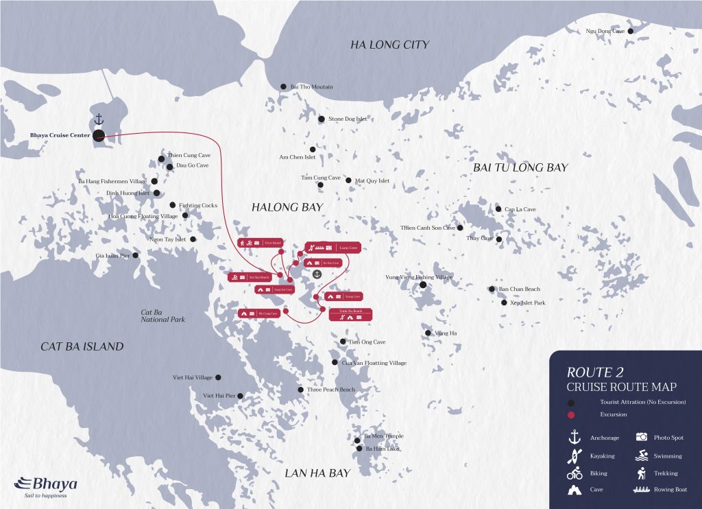
Halong Bay is divided into four designated cruising corridors. Each one is managed to protect the UNESCO landscape, control vessel flow, and give travellers a distinct experience. The route your cruise follows determines which caves and islands you visit, how crowded the anchorage feels, and what the pace of each day looks like.
All four routes depart from the Cruise Port at Tuan Chau Marina. From there, they fan out across different sections of the bay, each revealing a different character of the same seascape.
| Route | Character | Key Sites | Best For | Crowd Level |
|---|---|---|---|---|
| Route 1 | Classic highlights | Thien Cung Cave, Dau Go Cave, Dinh Huong Islet, Trong Mai Islet | Day cruises, first-timers with limited time | Moderate |
| Route 2 | Extended natural discovery | Ti Top Island, Sung Sot Cave, Luon Cave, Soi Sim Island, Me Cung Cave | Overnight cruises, first-time visitors wanting variety | Higher |
| Route 3 | Cultural and ecological depth | Cua Van Fishing Village, Tien Ong Cave, Ang Du, Ba Ham Lake, Ba Men Temple | Couples, culture seekers, wellness travellers, photographers | Lowest |
| Route 4 | Remote and immersive | Outer caves, remote ecological zones, quiet fishing communities | Multi-night adventurous travellers (3 nights or longer) | Lower |
All cruise route details are for reference only and may vary by operator and season. Please confirm current itinerary maps with your cruise operator before booking.
How to Match Your Itinerary to the Right Zone?
The right route depends on how much time you have, how you prefer to spend it, and how important it is to share the bay with fewer other vessels.
- Route 1 suits travellers joining a half-day or full-day cruise who want a clear, accessible introduction to Halong Bay’s most recognisable formations. The itinerary covers iconic islets and two well-known caves within a compact circuit near the mainland.
- Route 2 is the most popular option for overnight cruisers visiting the bay for the first time. It covers more ground than Route 1 and includes Ti Top Island for a panoramic viewpoint climb, the impressive scale of Sung Sot Cave, and kayak access through Luon Cave’s narrow arch.
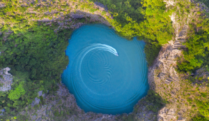
- Route 3 is the standout choice for 2026. It traces the bay’s cultural and ecological heart, taking in Cua Van Fishing Village, the quiet inlets of Ang Du, and the natural lake at Ba Ham Lake, a site that belonged to Lan Ha Bay before provincial administration divided the area between Quang Ninh and Hai Phong. The route also passes Tien Ong Cave, a lesser-visited grotto with considerable depth and atmosphere. Because it traces this old boundary, the route lets guests experience the scenery of both bay zones on a single itinerary.
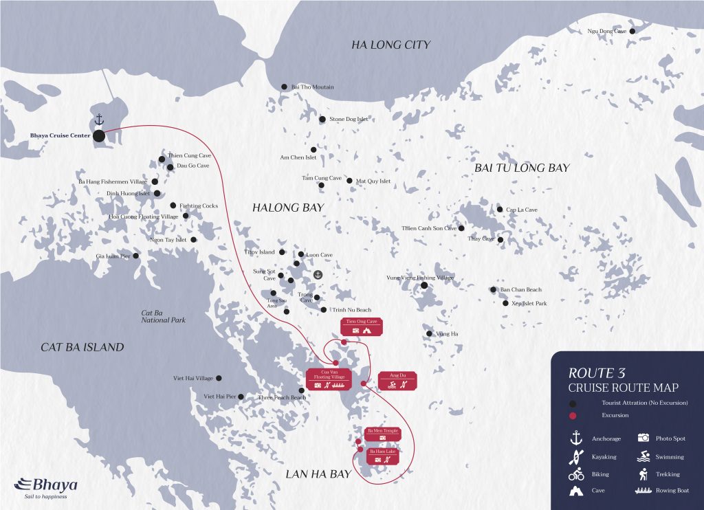
Bhaya Soul’s wellness-inclusive cruises follow Route 3, combining guided excursions through these quieter zones with onboard yoga, sunrise Tai Chi on deck, spa treatments, and health-conscious cuisine.
- Route 4 is for travellers with three nights or more who want to reach the bay’s most remote sections. Fewer vessels operate this far out, and the scenery transitions from famous landmarks to a wilder, less-defined landscape of ancient limestone formations, ecological zones, and fishing communities that see very little tourist traffic.
For a complete breakdown of each route with detailed maps, stop-by-stop itineraries, and guidance on which Bhaya voyage matches each corridor, read the full Halong Bay cruise routes guide.
Top Caves and Islands on the Halong Bay Map
The caves and islands of Halong Bay are spread across a large area, and not all of them feature on every cruise. Knowing roughly where each site sits on the map helps you confirm whether a given itinerary actually visits the places you came to see.
The most visited caves cluster in the southern and central sections of the core zone, within 15 km (9 miles) of Bai Chay Pier. Floating villages and outer-zone sites require a longer route or a vessel permitted to sail further from the main harbour.
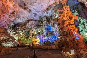
Sung Sot Cave, known in English as Surprise Cave, is the bay’s largest and most visited cavern. It sits on Bo Hon Island and holds two large chambers, with the second opening to a view over the surrounding water. Luon Cave, a short distance away, can only be reached by kayak or bamboo boat, passing through a narrow limestone arch into a sheltered lagoon. These two sites together capture the full range of cave experiences the bay offers.
For floating village access, Cua Van is the oldest fishing community in the bay and the most frequently visited. Vung Vieng, positioned further toward Bai Tu Long Bay, offers a quieter and less-frequented alternative.
| Attraction | Zone | Approx. Distance from Bai Chay Pier | Highlight |
|---|---|---|---|
| Sung Sot (Surprise) Cave | Halong Bay core | Approx. 14 km (8.7 miles) | Largest cave in the bay, two interconnected chambers |
| Thien Cung Cave | Halong Bay core | Approx. 4 km (2.5 miles) | Intricate stalactite formations, near the main harbour |
| Luon Cave | Halong Bay core | Approx. 14 km (8.7 miles) | Kayak-only access through a low limestone arch |
| Me Cung Cave | Halong Bay core | Approx. 13 km (8 miles) | A winding, labyrinthine cave system |
| Ti Top Island | Halong Bay core | Approx. 8 km (5 miles) | 360-degree panoramic viewpoint from the summit |
| Vung Vieng Village | Bai Tu Long Bay | Approx. 30 km (19 miles) | Authentic floating fishing community |
| Cua Van Village | Halong Bay core | Approx. 15 km (9 miles) | Oldest floating village in the bay |
| Trinh Nu Cave | Halong Bay core | Approx. 15 km (9.3 miles) | Known as Virgin Cave, tied to a well-known local legend |
All distances are approximate and may vary by cruise route and departure point. Please confirm site access with your operator before booking.
Conclusion
Understanding the Halong Bay map is the foundation of a well-planned trip. Knowing which of the three bays your route covers, which caves and islands sit on your itinerary, and how departure points connect to what you experience onboard turns a general interest in the bay into a precise and confident booking.
Whether you are drawn to the iconic limestone formations of the core zone, the untouched beaches of Lan Ha Bay, or the open water and restorative pace of a longer wellness voyage at sea, the right cruise length and departure point translate directly into which zones and sites you actually experience.
Frequently Asked Questions
What is the difference between Halong Bay, Lan Ha Bay, and Bai Tu Long Bay on the map?
The three bays form a connected seascape in the Gulf of Tonkin but differ in location, administration, and visitor experience. Halong Bay is the central UNESCO World Heritage area near Halong City and attracts the highest number of visitors. Lan Ha Bay lies southeast of Halong Bay near Cat Ba Island under Hai Phong’s administration, offering a quieter atmosphere while accommodating a growing number of cruise itineraries. Bai Tu Long Bay extends to the northeast and is known for its remote scenery, traditional fishing villages, and comparatively low tourist traffic.
How far is Halong Bay from Hanoi, and how long does the journey take?
Halong Bay is located approximately 170 km (106 miles) from Hanoi. Using the Hanoi–Halong Expressway, the journey typically takes around 2.5 hours under normal traffic conditions, although travel times may vary. Daily shuttle buses and private transfers connect central Hanoi with Tuan Chau Marina, the primary departure point for most boutique and luxury cruises.
What are the main departure points on the Halong Bay map?
Tuan Chau Marina, located approximately 7 km (4 miles) west of central Halong City, serves as the main departure point for most boutique and luxury cruise operators. Another departure location is Halong International Cruise Port near Bai Chay, which continues to accommodate selected cruise services and international cruise ship arrivals.
Which caves and islands are closest to the main pier on the Halong Bay map?
Thien Cung Cave is among the closest attractions to the main harbour, situated approximately 4 km (2.5 miles) away. Ti Top Island lies around 8 km (5 miles) from the pier and is a popular stop for swimming and panoramic views. Further into the bay, Sung Sot Cave and Luon Cave are located approximately 14 km (8.7 miles) from Bai Chay Pier and are commonly included in overnight cruise itineraries.
Are any parts of Halong Bay restricted or protected on the map?
Yes. The UNESCO-designated core zone is protected by strict regulations governing vessel routes, anchorage locations, and permitted visitor activities. Cruise operators must follow approved navigation corridors, while certain environmentally sensitive areas remain closed to tourism. Similar but distinct management rules also apply in Lan Ha Bay and Bai Tu Long Bay, with regulations periodically updated to support conservation efforts.